Discover MicroStation
Building Your Cities, Campuses, and Airports
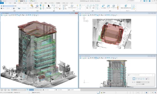
MicroStation is the instrument professionals rely on to design, model, and manage the projects that your community relies on. From an educational campus to an airport, public works projects or transportation optimization, MicroStation not only builds the foundation of infrastructure design projects but is the foundation of your design and engineering solution.
Providing you power, flexibility, and best-in-class tools, MicroStation makes it easy to work the way you want, leaving you time to do what you do best. With MicroStation, minimize risks, accelerate automation, and win more work.
Supporting Your Entire Workflow
| Design
Create geospatially enabled 2D and 3D drawings for infrastructure projects, and deliver them on time and on budget, even as project complexities and scale increase.
| Communicate
Produce faster/better documents ready to communicate your design intent. Documents are industry compliant so you can stamp designs with ease and confidence.
| Deliver
A common environment connects your tools, data, and teams, so that you can reliably deliver on even the most demanding projects.
Plan and Model Your Cities and Building Projects with Confidence
Remarkable AEC designs are made possible by remarkable technology solutions
Find out how designers and architects use MicroStation to:
- Improve design accuracy
- Bridge the technology gap
- Increase collaboration across disciplines
- Design within real-world context
- Move from 2D CAD to 3D BIM workflows
- Minimize errors and costly on-site changes
.png)
MicroStation is the CAD of Choice for Infrastructure Design Projects

Model anything,
anywhere
MicroStation creates conceptual and detailed drafting, drawing, modeling, and detailing for any industry, with geospatial context.
.png?width=208&height=250&name=file-formats@4x%20(2).png)
Read and Consolidate anything
MicroStation supports and integrates more than 7x the number of file formats than our competitors without translations.

Report everything to inform everyone
MicroStation feeds accurate, real-time CAD data wherever you need, including your digital twin.
Learn How Cities, Campuses, and Airports Users Have Utilized MicroStation for Design Projects
Kokusai Kogyo Used MicroStation to Create 3D Models for 17 Cities Nationwide
Project PLATEAU aims to develop Japan’s largest-scale 3D city models for 56 cities and promote their use by releasing them as open platform data for urban activities and smart-city management.
Lifschutz Davidson Sandilands Relies on MicroStation for Architecture Projects
MicroStation enables architects to spend time designing and solving problems instead of performing administrative tasks.
.png?width=380&height=300&name=MS_Arch_EBook_11.23_Tablet_right%20(1).png)
That’s why leading architects, designers, and engineers trust MicroStation to produce high-quality drawings and 3D models for their AEC projects around the globe. MicroStation is the industry-leading 2D and 3D computer-aided design (CAD) software used for creating precise, fast, accurate, and reliable infrastructure designs, and construction-ready deliverables for projects of any scale saving time, reducing costs, and helping you win more projects.
Request Your e-book:
Ready to Bring Your Vision to Life?
MicroStation is the only computer aided design software for infrastructure design, helping architects and engineers like you bring their vision to life, present their designs to their clients, and deliver their projects to the community.


.jpg?width=500&height=282&name=CAD_MicroStation_LDS%20Success%20Story%20image%201%20(1).jpg)
